bin

Saigon River floodplain, Binh Duong, Vietnam

Sponsored by

Viet Nam, Binh Duong Province

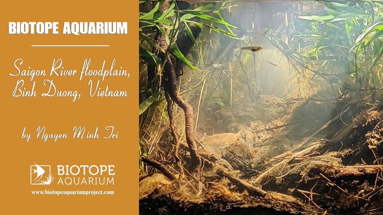
The Saigon River is a major river in southern Vietnam, approximately 256 km long. It originates near Phum Daung in southeastern Cambodia and flows through the provinces of Binh Phuoc, Tay Ninh, and Binh Duong. Passing through Ho Chi Minh City, it eventually merges with the Đong Nai River at the Nha Be junction before flowing into the South China Sea.

The river regularly floods nearby land, forming floodplains along its course. Periodic flooding brings nutrient-rich sediments and organic matter, leading to an increase in plankton, insects, and other food sources. These areas are home to a wide range of fish species, including Dermogenys siamensis, my favorite fish.

Submitted by
Nguyen Minh Tri
Approved by
Heiko Blessin, Heok Hee Ng & Greg Martin
GPS
10.9245119, 106.6821289
Geographical region
Southeastern Asia
Drainage Basin
River catchment
Saigon
Water body type
Wetland
Water body name
Floodplain
Water body part
Water body course
Water body: tributary of
Tributary name

Videos above and below water

Water Chemistry

Water information

Water type
fresh-water
Water color
White water
Water transparency
Low
Concentration of sediments
High
Water temperature
28 °C
Water flow/curent
Slow

Chemical parameters

pH
7.0
Conductivity
GH
232 mg/l
dGH
KH
143 mg/l
dKH
Dissolved Oxygen

Substrate in nature

Sand
None
Pebble/Gravel
None
Stone
None
Stone form
Silt/Mud
Orange
Leaves
Many
Driftwood
Many
Submerged terrestrial vegetation
Yes

Aquatic Biotope

Date of collecting
26 February, 2024
Collecting area
Flooded area
Water depth
0,2m
Air temperature
28 °C
Sunlight
Partial shade

Environment

Environment
Affected by human activity
Agriculture
Agriculture
Advanced
Surrounding area

Binh Duong is located in southern Vietnam which belongs to tropical monsoon climate. Therefore, it is warm all year round with two distinct seasons, the rainy season (May to October) and the dry season (November to April). The rainy season is characterized by a significant amount of precipitation, whereas during dry season there is minimal rainfall. The average annual temperature is 27 °C, average annual precipitation is approximately 1960mm.

The area that I chose to recreate is a relatively shady place with canopy layers of tall trees along the edges that allow very little direct sunlight to pass, effectively preventing overheating so it’s usually cooler here. The lower floor of the biotope is surrounde

Underwater landscape

This is a whitewater biotope, so the water here is quite murky, light brown, and has poor visibility, especially in the deeper sections (30-70cm). A large number of tree roots, fallen branches,coconut shells and dead leaves are scattered throughout the muddy bottom. Sunlight shines through the gaps in the canopy, creating beautiful spotlight effects in the shallow water.

Almost no aquatic plants are present here due to the lack of direct sunlight and the murky water. The fish that live here are small, almost transparent, and very timid, making it difficult to get a clear photo of them. The fauna and flora lists are based on my own observations, so there may be more species in the biotope that are not listed.

Fishlist:

  • Dermogenys pusilla (Hemiramphidae)
  • Trichopsis vittata (Osphronemidae)
  • Oryzias minutillus (Adrianichthyidae)
  • Cyprinus carpio (Cyprinidae) – introduced
  • Aplocheilus panchax (Aplocheilidae)
  • Clarias macrocephalus (Clariidae)
  • Mastacembelus favus (Mastacembelidae)
  • Anabas testudineus (Anabantidae)
  • Oreochromis mossambicus (Cichlidae) – introduced

Molluscs:

  • Pila polita (Ampullariidae)
  • Filopaludina sumatrensis (Viviparidae)
  • Melanoides tuberculata (Thiaridae)
  • Radix rubiginosa (Lymnaeidae)

Crustacean list:

  • Somanniathelphusa sinensis (Gecarcinucidae)
  • Caridina flavilineata (Atyidae)

Wetland plants:

  • Murdannia keisak (Commelinaceae)
  • Colocasia esculenta (Araceae)

Terrestial plants:

  • Urochloa distachyos (Poaceae)
  • Digitaria ciliaris (Poaceae)
  • Cyrtomium falcatum (Polypodiaceae)
  • Caryota mitis (Arecaceae)
  • Barringtonia acutangula (Lecythidaceae)
  • Cocos nucifera (Arecaceae)
Threats to ecology

The river and its surrounding wetlands face multiple threats that impact its ecology. Some of the threats include:

  • Pollution: Uneducated people dumping trash in random places cause severe environmental issues. The trash, carried by wind or floodwaters, eventually contaminates river water, smothers aquatic habitats, chokes or strangles fish and birds, and destroys breeding grounds and shelters for various wildlife. Agricultural runoff, Factories and industrial plants discharge untreated treated wastewater into the river, polluting the water and harming aquatic life.
  • Habitat loss: Urban development along the Saigon River’s banks contributes to habitat loss. Wetlands and natural riparian zones have been replaced by infrastructure and residential areas.
  • Overfishing: Intensive fishing activities and sometimes destructive fishing methods like electrofishing (which is illegal) are used, threatening the biodiversity of the Saigon River by endangering various fish species and other aquatic organisms.
  • Invasive species: People may release harmful non-native species for religious purposes or due to accidental release, which can outcompete or prey on native species, leading to declines in biodiversity.

Riparian zone

Trees near the aquatic habitat
Many -

Bibliography

Sitography

→ Britannica

Comment by the expert

Heiko Blessin:

Heok Hee Ng: Accurate description of habitat. I took off half a point because one sentence is incomplete.

Greg Martin: Well researched.