bin

Pamba River, Kerala, India

Sponsored by

Indonesia, Kerala, India, Kuttanad Taluk

Ocean pollution caused by fertilisers is increasing at a fast rate. Since the 1970s the riverine input of nitrogen and phosphor into the sea has tripled leading to excessive algal growth in many regions, which in turn threatens valuable ecosystems such as coral reefs.

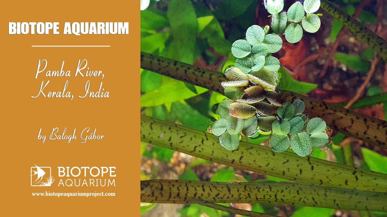
Researchers from the Leibniz Center for Tropical Marine Ecology (ZMT) have conducted measurements in a densely populated river basin in India. Besides agricultural use of the hinterland, there is another prominent reason of water pollution: the largest pilgrimage on earth – the Sabarimala Temple. During their studies the ZMT researchers made a surprising discovery – the Pamba River in the Indian state of Kerala is less contaminated by nutrients than, for example, the German Weser River.

A high population density, untreated sewage, use of fertilisers on farmland: Southeast Asian rivers are highly contaminated with nutrients such as nitrogen and phosphorus. During the monsoon season torrential rains wash large quantities.

Submitted by
Balogh Gábor
Approved by
Friedrich Bitter & Sujoy Banerjee
GPS
9.4833288, 76.4094238
Geographical region
Southeastern Asia
Drainage Basin
Arabian Sea
River catchment
Pamba river
Water body type
River
Water body name
Pamba river
Water body part
Channel
Water body course
Middle course
Water body: tributary of
River
Tributary name
Manimala

Videos above and below water


Warning: Undefined variable $fish_parent in /home/biotopea/public_html/wp-content/themes/bap/content-bin.php on line 55

Water Chemistry

Water information

Water type
Water color
Black water
Water transparency
Medium
Concentration of sediments
Low
Water temperature
26 °C
Water flow/curent
Slow

Chemical parameters

pH
7
Conductivity
60
GH
6 mg/l
dGH
KH
5 mg/l
dKH
Dissolved Oxygen
540 %

Substrate in nature

Sand
Reddish
Pebble/Gravel
Mixed
Stone
Mixed
Stone form
Irregular
Silt/Mud
None
Leaves
Few
Driftwood
Few
Submerged terrestrial vegetation
Yes

Aquatic Biotope

Date of collecting
24 April, 2024
Collecting area
Backwaters
Water depth
Air temperature
26 °C
Sunlight
Partial shade

Environment

Environment
Untouched
Surrounding area

Kerala called Keralam in Malayalam, it is a state on the Malabar Coast of India.It was formed on 1 November 1956, following the passage of the States Reorganisation Act, by combining Malayalam-speaking regions of the erstwhile regions of Cochin, Malabar, South Canara, and Travancore.

Spread over 38,863 km2 Kerala is the 21st largest Indian state by area. It is bordered by Karnataka to the north and northeast, Tamil Nadu to the east and south, and the Lakshadweep Sea to the west. With 33 million inhabitants as per the 2011 census, Kerala is the 13th-largest Indian state by population. It is divided into 14 districts with the capital being Thiruvananthapuram.

Malayalam is the most widely spoken language and is also the official language of the state. The Malabar region, in the northern part of Kerala, had been a part of the Madras province of British India, which later became a part of the Madras State post-independence. After the States Reorganisation Act, 1956, the modern-day state of Kerala was formed by merging the Malabar district of Madras State (excluding Gudalur taluk of Nilgiris district, Lakshadweep Islands, Topslip, the Attappadi Forest east of Anakatti), the taluk of Kasaragod (now Kasaragod District) in South Canara, and the erstwhile state of Thiru-Kochi (excluding four southern taluks of Kanyakumari district, and Shenkottai taluks).

Situated along the southwest corner of India, the state of Kerala is in the tropical belt. The varied topographical features coupled with high rainfall favoured the formation of different habitats such as the montane temperate forests (Shola) and grassland to the lowland mangroves along the estuaries and sea coasts. Each vegetation type has its own species composition. A remarkable feature of the state is the formation of tropical rain forests along the windward side of the Western Ghats, known for the rich biodiversity. Though the area forms only 1.18% of the country, nearly one fourth of the flowering plants recorded are reported to occur in Kerala.

Recent studies on the flora of districts, protected areas, taxonomic revision of families as well as genera described many new taxa. Every year new species as well as new record of occurrences are recorded from Kerala. Though APG system is adopted in modern plant systematic studies, the Bentham and Hooker’s system is still followed in general floristic studies as well as for the arrangements of specimens in Indian Herbaria. The E-flora of Kerala is an attempt to provide updated account of the flowering plants of Kerala.

Underwater landscape

The watercourse this area have quite a lot of vegetation above and below the water. They are mainly grasses and reeds. There are also a lot of trees. A large amount of greenery immersed in water, as well as the roots of trees, shrubs and grasses give this place a very specific character.

The winter contains stones often covered with algae, river sand and sunken pieces of wood of various sizes. The amount of sediment largely depends on the season.

Fishlist:

  • Carinotetraodon travancoricus (Tetraodontidae)
  • Dawkinsia apsara (Cyprinidae)
  • Macrognathus circumcinctus (Mastacembelidae)


Plantlist:

  • Limnophila sessiliflora (Plantaginaceae)
Threats to ecology

India’s climate is determined by the subtropical monsoon, which is characterized by heavy summer rain – this is when almost the entire year’s precipitation falls. Spring is extremely hot and dry. As we move east, the amount of precipitation increases, in the northeast, due to the influence of the mountains, there is one of the wettest points on Earth, Cherrapunji – the record amount of precipitation is more than 22.000mm!

At the same time, in the inner parts of the peninsula – due to the influence of the Western Ghats – a desert or dry savannah climate also occurs. Vertical zonation can be observed in the Himalayas, and high mountain climates are characteristic of the higher areas.

Large river valleys played a major role in the history of the Hindustani peninsula, where significant civilizations developed, taking advantage of the agricultural opportunities offered by the lowlands and the available water. The rivers with abundant water flow from the Himalayas to the Arabian Sea in the east and the Bay of Bengal in the west.

Most of the Indus flows in the territory of Pakistan today, while the Ganges forms the axis of the Hindustani lowlands and is still one of the most densely populated areas in the region. The Brahmaputra, which flows into the Ganges, is also significant, and its destructive floods are frequent. Due to the unevenly distributed precipitation typical of the monsoon, the flow of the rivers is very fluctuating.

Riparian zone

Trees near the aquatic habitat
Many -

Comment by the expert

Friedrich Bitter: Information supported by videos or photos would be much more effective than information in written form alone.

Sujoy Banerjee: Actual Videos of the Biotope can be researched for the Aquarium setup. There are specific research papers on the Pamba River it self which are a very good reference point. Also the river has large variety of fish living together ranging from Labeo, Dawkinsia, Salmostoma, Barilius, Danio, Rasboras, Garra, Bhavania, Mesonemacheilus, Mystus, Xenentodon, Parambassis, Nandus, Pristolepis, Etroplus, Glossogobius, Channa, Tetradon etc. So one can make a very well balanced Biotope Aquarium from this River keep a large variety of fishes as well.