bin

Bayou Lafourche, Mississippi River, Louisiana, USA

Sponsored by

United States, Louisiana, Lafourche

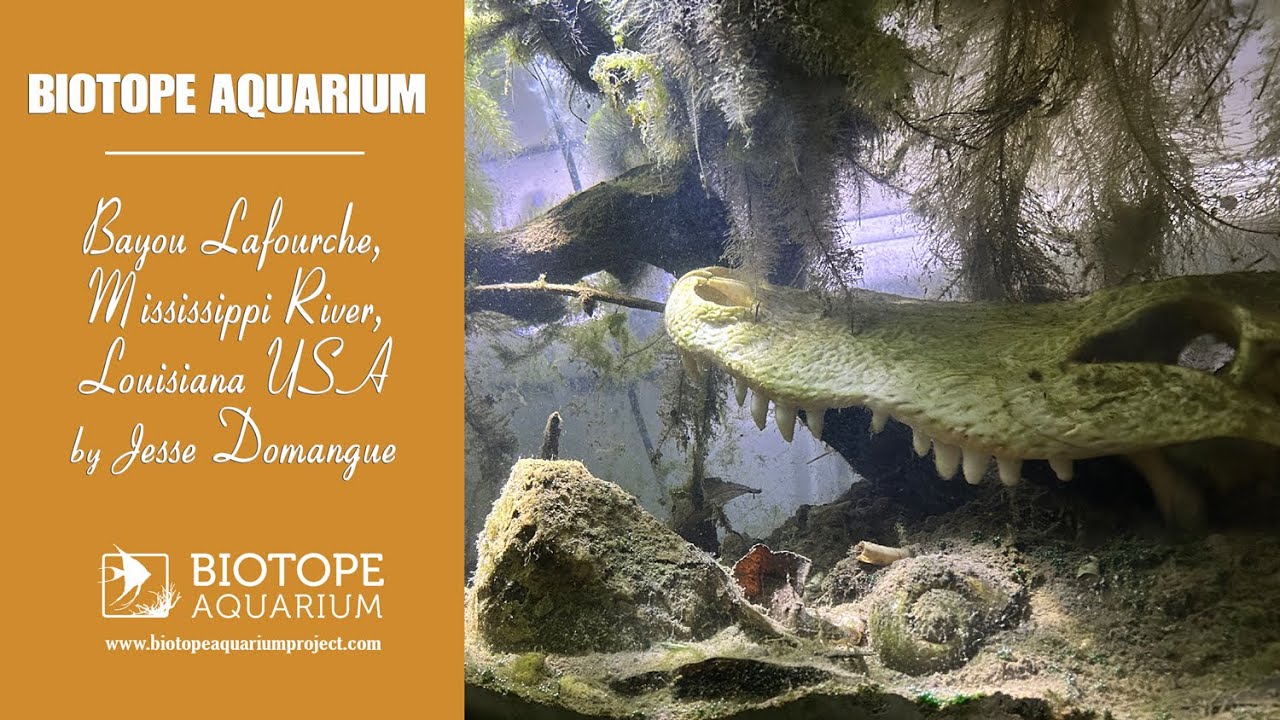
Bayou Lafourche stretches 170km starting from the town of Donaldsonville and draining into the Gulf of America. The word Lafourche means “ the fork” and the bayou splits off from the Mississippi river. Today 3Mln residents draw water from this bayou. Some of the wildlife found here are : waterfowl, alligators, catfish, snakes, and nutria rats.

The water hyacinth is an invasive floating plant which at times will clog the water ways. The water is heavy with tannins and visibility is only inches. I was born in Raceland Louisiana right on the water.

Submitted by
Jesse Domangue
Approved by
Lawrence Kent, Fritz Rohde & John T. Baxter
GPS
29.7292690, -90.6009674
Geographical region
Northern America
Drainage Basin
Barataria Basin
River catchment
Mississippi River
Water body type
Channel
Water body name
Bayou Lafourche
Water body part
Outflow
Water body course
Lower course
Water body: tributary of
Stream
Tributary name
Bayou Blue

Videos above and below water


Warning: Undefined variable $fish_parent in /home/biotopea/public_html/wp-content/themes/bap/content-bin.php on line 55

Warning: Undefined array key "additional_species" in /home/biotopea/public_html/wp-content/themes/bap/functions/bap-fields.php on line 349

Water Chemistry

Water information

Water type
fresh-water
Water color
Black water
Water transparency
Low
Concentration of sediments
Medium
Water temperature
78 degrees f °C
Water flow/curent
Slow

Chemical parameters

pH
7.0
Conductivity
417
GH
100 mg/l
dGH
KH
dKH
Dissolved Oxygen
0.00054 %

Substrate in nature

Sand
None
Pebble/Gravel
None
Stone
None
Stone form
Silt/Mud
Brown
Leaves
Adundant
Driftwood
Many
Submerged terrestrial vegetation
Yes

Aquatic Biotope

Date of collecting
27 April, 2025
Collecting area
River bank
Water depth
0,2m
Air temperature
28 °C
Sunlight
Full sun

Environment

Environment
Human settlements
Human settlements
Urban area
Surrounding area

Bayou Lafourche is very narrow in certain places the banks are lined with oak and cypress trees as well as houses. Often the older trees will fall over into the water after strong storms. There are numerous small bridges crossing the bayou creating cover for fish and alligators.

Underwater landscape

The water is always a deep brown from a high concentration of tannins. After a strong storm the muddy substrate is churned up and the water becomes cloudy. If the bottom was visible there would be dead leaves, branches, and stumps of broken trees. Close to the banks floating plants will collect draping their roots down.

Fish list:

  • Gambusia affinis (Poeciliidae)
  • Lepomis macrochirus (Centrachidae)
  • Lepisosteus oculatus (Lepisosteidae)
  • Ictalurus punctatus (Ictalurids)

Crustacean list:

  • Palaemonetes Paludosus (Palaemonidae)
  • Procambarus clarkii (Cambaridae)

Aquatic plant:

  • Pontederia Crassipes (Pontederiaceae)
  • Pistia Stratiotes (Araceae)
Threats to ecology

Bayou Lafourche is the source of our tap water and must be protected from spills and trash dumping. Some of the invasive species here are apple snails, nutria, and the water hyacinth.

Riparian zone

Trees near the aquatic habitat
Many -