bin
Cape Kabogo, Lake Tanganyika, Tanzania
Tanzania, Kigoma Region, Kigoma Rural
Geographical Context: Located on the eastern Tanzanian coast, south of the Malagarasi River basin, Cape Kabogo (5°27’42″S, 29°44’50″E) is a dynamic transition zone within the East African Rift Valley. Lake Tanganyika is one of the world’s oldest and deepest freshwater ecosystems, providing a remarkably stable environment that has remained largely unchanged for millions of years.
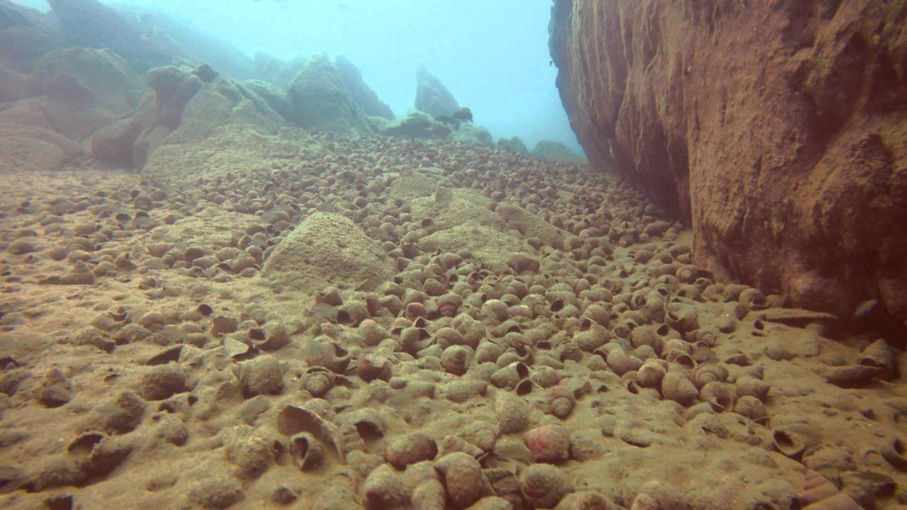
Physical Dynamics: The underwater landscape forms an intermediate zone where the steep, rocky littoral shoreline gradually transitions into deep sandy beds. In shallow water (0-15 m), wave action keeps large boulders free of silt. As the slope decreases, the rocks become smaller, forming rubble fields that gradually merge with fine, alkaline sand.
A defining feature of this habitat is the extensive accumulation of empty Neothauma tanganyicense gastropod shells scattered across the sandy plains. The water is exceptionally clear, with visibility reaching up to 20 m, high dissolved oxygen levels, a stable pH of 8.5-9.0, and temperatures ranging from 24-27°C.
- Submitted by
- Rens van Duren
- Approved by
- Ad Konings & Anton Lamboj
- GPS
- -5.4616671, 29.7472229
- Geographical region
- Eastern Africa
- Drainage Basin
- River catchment
- Water body type
- Lake
- Water body name
- Tanganyika
- Water body part
- Open water
- Water body course
- Water body: tributary of
- Tributary name
Videos above and below water
Warning: Undefined variable $fish_parent in /home/biotopea/public_html/wp-content/themes/bap/content-bin.php on line 55
Water Chemistry
Water information
- Water type
- Freshwater
- Water color
- Clear water
- Water transparency
- High
- Concentration of sediments
- Low
- Water temperature
- 24-27°C °C
- Water flow/curent
- Slow
Chemical parameters
- pH
- 8.8
- Conductivity
- 620
- GH
- dGH
- 11 °dGH
- KH
- dKH
- 18.5 °dKH
- Dissolved Oxygen
Substrate in nature
- Sand
- Pebble/Gravel
- Beige
- Stone
- Reddish
- Stone form
- Silt/Mud
- Beige
- Leaves
- None
- Driftwood
- None
- Submerged terrestrial vegetation
- None
Aquatic Biotope
- Date of collecting
- 22 May, 2026
- Collecting area
- Water depth
- Air temperature
- Sunlight
Environment
- Environment
- Untouched
- Surrounding area
Cape Kabogo is situated within the steep, mountainous landscape of the Albertine Rift, the western branch of the East African Rift Valley, in the Kigoma Region of Tanzania. The terrestrial environment is characterized by dramatic escarpments, dense coastal forests, and steep hillsides that descend abruptly into the lake. This rugged topography creates a highly isolated coastline with minimal human infrastructure. To the north, the nearby Malagarasi River basin influences the regional hydrology and contributes to the ecological diversity of the surrounding landscape.
- Underwater landscape
Beneath the surface, Cape Kabogo features a dynamic transition zone where wave-swept rocky cliffs and massive littoral boulders give way to deep, sediment-rich sandy beds at depths of approximately 0–15 m. As the gradient decreases away from the shoreline, the large rock formations gradually break into smaller rubble fields before merging with vast expanses of fine, alkaline sand.
The sandy plain is distinguished by extensive accumulations of empty Neothauma tanganyicense snail shells, forming dense shell beds that provide the primary structural habitat within an otherwise open, vegetation-free underwater landscape.
Fish:
- Lamprologus callipterus (Cichlidae)
- Telmatochromis vittatus (Cichlidae)
- Neolamprologus similis (Cichlidae)
Mollusc:
- Neothauma tanganyicense (Viviparidae)
- Threats to ecology
The ecological balance of Cape Kabogo faces increasing threats from regional population growth, climate change, and habitat degradation. Deforestation and agricultural expansion on the surrounding hillsides have accelerated soil erosion, increasing sediment runoff into the lake. This siltation can cover littoral rocks and reduce the growth of aufwuchs, the algae-based biofilm that forms an essential food source for many cichlid species.
Rising global temperatures have also intensified thermal stratification in Lake Tanganyika, reducing the natural upwelling of nutrient-rich deep water. This decline in nutrient availability lowers primary productivity and may negatively affect the reproduction and long-term survival of the lake’s endemic cichlid communities.
Riparian zone
- Trees near the aquatic habitat
-
None -
Bibliography
-
Tanganyika cichlids in their natural habitat
by Ad Konings
ISBN 0-9668255-0-0
Comment by the expert
Ad Konings: Proper description of the habitat, but many more fish species occur at Cape Kabogo. Also, T. vittatus does not occur at Cape Kabogo; it is T. bifrenatus, but is not an important mistake.