bin
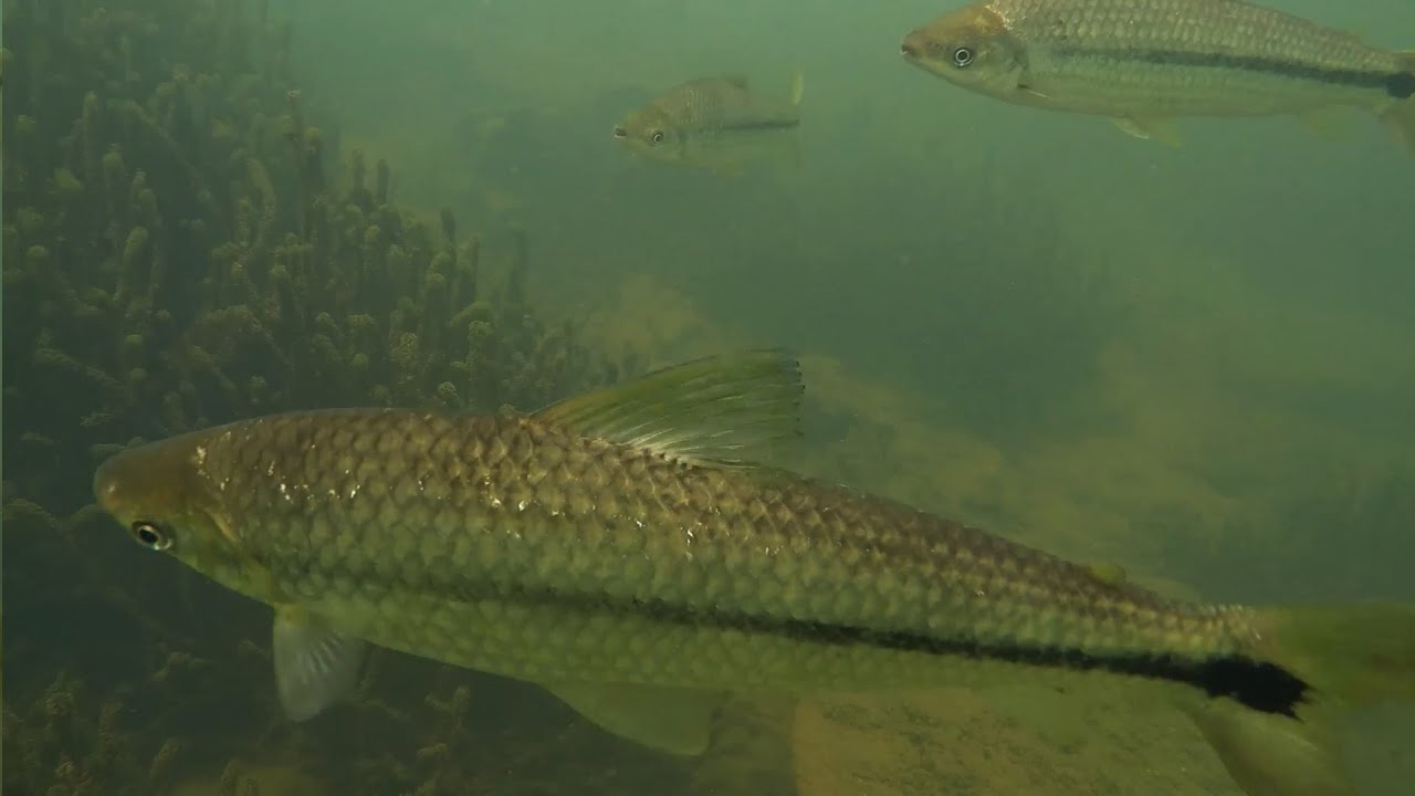
Corrientes, Paraná flooded savanna, Argentina
Argentina, Corrientes, Corrientes
The Paraná River originates in central South America, from the southeastern plateau of Brazil, joins the Uruguay River and empties into the Atlantic Ocean through the Rio de la Plata Estuary. It is the longest river on the continent after the Amazon.
The length of the river is 4,880 km, its basin is 2.582,672 km², and the annual average flow is 17,290 m³/s. The catchment covers most of southeastern Brazil, Paraguay, Bolivia and Argentina.
It takes the name Upper Parana from its source to the junction with the Uruguay River. It is formed by the union of the Upper Parana Grand and Paranaíba tributaries. Flowing south, it receives the Tiete, Paranapanema and Iguaçu rivers on the right. After taking the Iguazu River, it forms the Brazil-Paraguay border and later the Argentina-Paraguay border.
Apistogramma borelli, a species that I love very much, lives in the region. This area, which is a flat and wide savanna, hosts small ponds along with the Parana River floods. Its waters are cool and partially rich in minerals. Meadow plants are abundant in the region; Such as Helanthium tenellum, Pontederia and Eleocharis sp.
- Submitted by
- Arif Hikmet Başeğmez
- Approved by
- Roberto E. Reis & Flávio Lima
- GPS
- -27.4659805, -58.7140160
- Geographical region
- South America
- Drainage Basin
- Parana River
- River catchment
- Parana River
- Water body type
- Wetland
- Water body name
- Parana river flood pond
- Water body part
- Flood plain
- Water body course
- Upper course
- Water body: tributary of
- Wetland
- Tributary name
- Parana River
Videos above and below water
Warning: Undefined variable $fish_parent in /home/biotopea/public_html/wp-content/themes/bap/content-bin.php on line 55
Water Chemistry
Water information
- Water type
- fresh-water
- Water color
- Clear water
- Water transparency
- High
- Concentration of sediments
- Low
- Water temperature
- 25 °C
- Water flow/curent
- Slow
Chemical parameters
- pH
- 6.5
- Conductivity
- 180
- GH
- 8 mg/l
- dGH
- KH
- 4 mg/l
- dKH
- Dissolved Oxygen
Substrate in nature
- Sand
- White
- Pebble/Gravel
- Mixed
- Stone
- Mixed
- Stone form
- Silt/Mud
- Brown
- Leaves
- Few
- Driftwood
- Few
- Submerged terrestrial vegetation
- Yes
Aquatic Biotope
- Date of collecting
- Collecting area
- Water depth
- Air temperature
- Sunlight
Environment
- Environment
- Affected by human activity
- Affected by human activity
- Pollution
- Pollution
- Little
- Surrounding area
The Paraná River originates in central South America, from the southeastern plateau of Brazil, joins the Uruguay River, and empties into the Atlantic Ocean through the Rio de la Plata Estuary. It is the longest river on the continent after the Amazon.
The length of the river is 4,880 km, its basin is 2.582,672 km², and the annual average flow is 17,290 m³/s. The catchment covers most of southeastern Brazil, Paraguay, Bolivia, and Argentina.
It takes the name Upper Parana from its source to the junction with the Uruguay River. It is formed by the union of the Upper Parana Grand and Paranaíba tributaries. Flowing south, it receives the Tiete, Paranapanema, and Iguaçu rivers on the right. After taking the Iguazu River, it forms the Brazil-Paraguay border and later the Argentina-Paraguay border.
The Iguazu River separates the Argentina-Brazil-Paraguay countries from each other in the area where it joins with Parana. Before merging with the Parana River, it forms the Iguazú Falls.
- Underwater landscape
In the rainy season, rising waters cover the Corrientes savannas. The ground is covered with flooded meadows and dry grass. It forms a brown soil or white fine sand substrate. The water is clean and clear. In times of flood, dry leaves and dry branches are carried to the ponds with the floods.
- Threats to ecology
Currently, the Paraná River ecosystem suffers from harmful effects triggered by indiscriminately exploitative human activities. Construction projects that build dams and other artificial barriers along the Paraná River have done irreparable damage to the river’s ecosystems.
During the construction of the Itaipu Hydroelectric Dam in Paraná in 1979, the Guairá Falls completely drowned in the process of creating the dam. Such dams and waterways have also affected the aquatic and terrestrial habitats of native flora and fauna, as they endanger the migration routes of fish and even displace thousands of local people. Rapid deforestation along the riverbanks for agricultural expansion has contributed to the erosion of the land. as a result, large amounts of eroded sediment and debris are loaded into the river and the quality of Paraná’s water resources is degraded.
About 88% of the original area of the Atlantic Forest around the Paraná River has been lost, compromising the existence of much of the region’s native flora and fauna. A scientific report claims that around 50% of fish species in Paraná are devastated in just 20 years. An important species of the Paraná River ecosystem and an important link in the food chain, Sábalo is also weakened by exploitative fishing. Unfortunately, these fishermen do not realize that with their irresponsible practices, they are not only seriously damaging the ecosystem.
Riparian zone
- Trees near the aquatic habitat
-
Few -