bin

Sungai Kolok Floodplain, South Thailand

Sponsored by

Thailand, Ban Buketa, Narathiwat

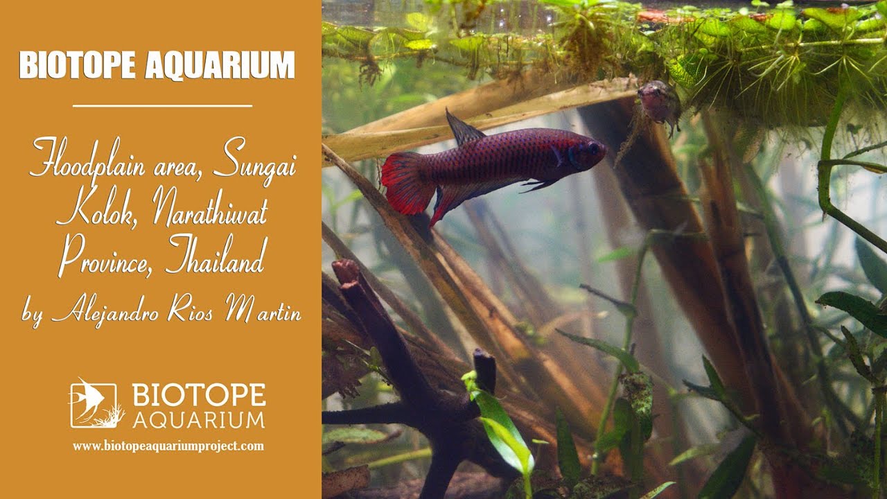
Ban Buketa (Narathiwat, Thailand) lies within the Sungai Kolok River basin and transforms into a floodplain during the rainy season. Its shallow waters, filled with floating or submerged vegetation, typically exhibit a pH between 5.5 and 7.0, low oxygen levels, and variable conductivity. During the monsoon season, decomposing plant matter releases tannins that stain the water a brown-amber color, creating an acidic, low-light environment – ideal for species such as Betta imbellis.

As the waters recede after the monsoon, they become more concentrated, intensifying these conditions. The aquatic vegetation includes Neptunia oleracea, Limnocharis flava, Limnophila spp., and Murdannia keisak, which play key roles in nutrient cycling and provide structural support for bubble nests.

The associated fauna – such as Boraras maculatus, Limnopilos naiyanetri, and other anabantoids and macroinvertebrates – reflects a highly structured ecosystem, adapted to trophic conditions shaped by seasonal fluctuations in tannin levels.

Submitted by
alejandro Rios Martin
GPS
5.8466668, 101.8927765
Geographical region
Southeastern Asia
Drainage Basin
South China Sea (near the Thai-Malaysian border)
River catchment
Sungai Kolok
Water body type
Wetland
Water body name
Kolok Floodplain
Water body part
Flood plain
Water body course
Middle course
Water body: tributary of
Wetland
Tributary name

Videos above and below water


Warning: Undefined variable $fish_parent in /home/biotopea/public_html/wp-content/themes/bap/content-bin.php on line 55

Warning: Undefined array key "additional_species" in /home/biotopea/public_html/wp-content/themes/bap/functions/bap-fields.php on line 349

Water Chemistry

Water information

Water type
fresh-water
Water color
Mixed water
Water transparency
Medium
Concentration of sediments
High
Water temperature
25-27 °C
Water flow/curent
None

Chemical parameters

pH
5
Conductivity
20
GH
3 mg/l
dGH
KH
1 mg/l
dKH
Dissolved Oxygen
3 %

Substrate in nature

Sand
Beige
Pebble/Gravel
Stone
Brown
Stone form
Silt/Mud
Beige
Leaves
Many
Driftwood
Few
Submerged terrestrial vegetation
Yes

Aquatic Biotope

Date of collecting
Collecting area
Flooded area
Water depth
0,5m
Air temperature
29 °C
Sunlight
Full sun

Environment

Environment
Affected by human activity
Deforestation
Deforestation
Advanced
Surrounding area

The environment of Ban Buketa, in Waeng District (Narathiwat, Thailand), is a transition zone between natural ecosystems and agricultural areas, characterized by pronounced climatic seasonality and a wide variety of habitats. It is a mosaic landscape composed of fragments of tropical rainforest, swampy zones, inland peatlands, and temporary water bodies that appear during the rainy season.

During the wet months, the land becomes partially flooded, forming ponds, channels, and interconnected marshy areas. In contrast, during the dry season these water bodies shrink, concentrating organic matter and tannins, which alters water quality. This seasonal cycle creates highly specific conditions—such as low oxygenation and high acidity – that favor species adapted to extreme environments.

The surrounding vegetation includes native trees, palms, hydrophilic shrubs, and aquatic species, while in more altered areas rubber and oil palm plantations predominate. Human activity has transformed part of the landscape, generating a fragmented matrix where natural zones, cultivated fields, and small rural settlements coexist.

The terrestrial and aquatic fauna is diverse, including wetland birds, semi-aquatic reptiles, amphibians, insects, and small fish such as Betta imbellis. The hydrological dynamics, riparian vegetation, and organic inputs of the environment make Ban Buketa a complex, functional, and vulnerable ecosystem, where seasonal fluctuations define the key ecological conditions.

Underwater landscape

The underwater environment of Betta imbellis in Ban Buketa consists of shallow, calm waters rich in organic matter. The substrate, made up of decomposing leaf litter, submerged roots, and soft sediments, generates a high concentration of tannins that stain the water a dark brown and reduce visibility. These conditions fluctuate seasonally: during the rainy season the water is diluted and organic compounds disperse, while in the dry season acidity, low transparency, and scarcity of dissolved oxygen become more pronounced.

The aquatic vegetation is diverse and functional. Submerged plants such as Limnophila spp. and Barclaya longifolia provide shelter, shade, and hunting grounds. Floating species like Limnocharis flava and Neptunia oleracea shade the surface and serve as support for the bubble nests built by Betta imbellis. Along the waterlogged margins, the emergent species Murdannia keisak develops, stabilizing the habitat edges and adding structural complexity.

The faunal community includes small invertebrates such as Caridina spp., insect larvae, and the freshwater crab Limnopilos naiyanetri, which lives among roots and detritus. In addition, the small, peaceful cyprinid Boraras maculatus is commonly found in the same environments as Betta imbellis. Both species share the microhabitat, tolerate acidic, dark waters, and benefit from the dense vegetation cover for feeding and protection.

Altogether, this underwater environment represents a specialized ecosystem of low light and high organic load, where Betta imbellis and Boraras maculatus thrive thanks to their ability to adapt to oxygen-poor conditions and high seasonal variability.

Fish list:

  • Betta imbellis (Osphromenidae)
  • Boraras maculatus (Cyprinidae)

Crustacean list:

  • Limnopilos naiyanetri (Hymenosomatidae)

Aquatic plant list:

  • Salvinia cucullata (Salviniaceae)
  • Lemna (Araceae)

Wetland plant list:

  • Murdannia (Commelinaceae)

Terrestrial vegetation list:

  • Dipterocarpus (Dipterocarpaceae)
  • Calamus (Arecaceae)
  • Bambusa (Poaceae)
  • Elaeis (Arecaceae)
  • Nephrolepis (Nephrolepidaceae)
Threats to ecology

The ecosystem of Ban Buketa is facing increasing pressures from human activity. The expansion of rubber and oil palm plantations has fragmented the natural habitat, altering hydrological cycles and reducing water quality. The drainage of peatlands and the channelization of natural flows affect the ecosystem’s seasonal dynamics, which are crucial for the release of tannins and the maintenance of acidic conditions that favor species such as Betta imbellis.

In addition, the use of agrochemicals in nearby crops causes diffuse pollution that modifies pH and impacts aquatic fauna. The indiscriminate capture of ornamental fish, the introduction of exotic species, and deforestation further exacerbate the situation. These factors, combined with climate change, threaten the ecological stability of the area.

Altogether, these impacts reduce habitat connectivity, decrease aquatic vegetation, and alter the structure of the ecosystem, putting at risk specialized species that depend on dark, calm, and organic-rich waters. Conserving this environment requires protecting not only the water bodies but also their vegetation and natural cycles.

Riparian zone

Trees near the aquatic habitat
Few -

Comment by the expert

Heok Hee Ng: BIN description is lacking visual support for natural habitat.

Greg Martin: Good to see this comprehensive support video.