bin

Intermediate Rocky Habitat, Lake Tanganyika, Zambia

Sponsored by

Tanzania, Ujiji, Katete region

Lake Tanganyika is a tectonic rift valley lake. It is the second deepest lake in the world. Three inflows are Ruzizi, Malagarasi and Kalambo Rivers. One outflow is Lukuga River.

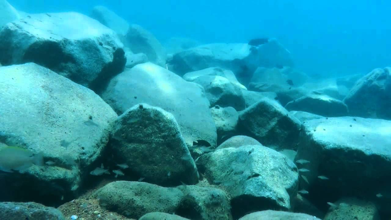
Lake is very famous for its highly diversed fauna and flora. It holds 250 species of cichlid fish and 150 non-cichlid species. Species of lake is very good example of adaptive radiation and explosive diversification. BIN is a point near Congo Border and it s 200-near to shore. It has a atmospheric rocky bottom structure and harbors lots of species.

Submitted by
Uğur Ruşen Doğan
Approved by
Ad Konings & Michael Salter
GPS
-8.2705002, 30.5719719
Geographical region
Eastern Africa
Drainage Basin
River catchment
Water body type
Lake
Water body name
Lake Tanganyika
Water body part
Water body course
Water body: tributary of
Tributary name

Videos above and below water

Water Chemistry

Water information

Water type
Fresh water
Water color
Clear water
Water transparency
Medium
Concentration of sediments
No
Water temperature
27.5 °C
Water flow/curent
Slow

Chemical parameters

pH
8.5
Conductivity
620
GH
12 mg/l
KH
20 mg/l
Dissolved Oxygen
90 %

Substrate in nature

Sand
Beige
Pebble/Gravel
Beige
Stone
Grey
Stone form
Irregular
Silt/Mud
no
Leaves
No
Driftwood
no
Submerged terrestrial vegetation
No

Aquatic Biotope

Date of collecting
18 march 2015
Collecting area
Shore line
Water depth
1,0m
Air temperature
28.5 °C
Sunlight
Full sun

Environment

Environment
Human settlements
Human settlements
some
Surrounding area

BIN is located about 1300-1500 meters far from shoreline. Narrow and stony shoreline goes up with hills which covered with forests. There is a normal inclination rate after plain shoreline. Wet and dry season are seen in area. Human settlement is not seen on area.

Underwater landscape

BIN is an intermediate rocky bottom habitat of Lake Tanganyika which is about 5 meters depth. Rocks lie on each other or sand in habitat. Rocks sizes are variable ad not bigger than 1-2 meters. Rocks are gray or white color and curved edged. Sand is beige thin mixed type.

Rocks are partly covered with algae as a very weak thin layer. Sediment is not found much and can be seen on rocks in bottom like a dust on biocover. Connection places of sand and rocks in bottom are potential shelters for species which digs sand and build shelters for whole family. Gradual inclination can be seen from rocks towards sandy bottom.

BIN harbors lots of species as start depth of heavily populated area in intermediate habitats. Rocks provide shelters, feeding areas and breeding places for lots of species in habitat.


Fishes:

  • Altolamprologus calvus 
  • Altolamprologus compressiceps
  • Chalinochromis brichardi
  • Cunningtonia longiventralis
  • Tropheus moori 
  • Neolqmprologus sexfasciatus 
Threats to ecology

Climate change, pollution, deforestation and overfishing threaten the ecology, ecological stability and ecosystem of Lake Tanganyika.

Over the last century, warming water temperatures have caused changes to the lake’s ecosystems that threaten the fish species both endemic beautiful fish and the fish people depend on for food. In last 100 years, surface waters of Lake Tanganyika have warmed by 1.6 to 2.3° F (0.9 to 1.3°C). From these records, scientists are finding that Lake Tanganyika’s surface waters are warming more rapidly than its depths.

This has the effect of creating an even sharper gradient between the upper and lower layers of the lake, and thus creating an even greater barrier to wind-induced mixing.

On the other hand, number of people live in the lake’s drainage basin, and the overall populations are growing rapidly. The population growth in nearshore areas around Lake Tanganyika is nearly double the national’s average.

For the most part, the lake has relatively high quality water, except in a few areas where urban and industrial runoff has affected the lake. This is in part due to the lake’s enormous volume but this has a limit. The buffering capacity of the lake cannot handle more than a certain pollution load.

Deforestation, over-exploitation of the fishery and siltation caused by erosion from deforested areas are considered one of the main threats to the health of the lake. With increased population pressure, the ongoing problem of siltation, and now climate change added to the mix, fish stocks, biodiversity, and water quality are expected to decline.

The particles in the lake and those washing into it, through rivers, streams, shoreline erosion, and even pollution discharges, eventually settle out to the bottom along with the decomposed remains of aquatic organisms.

In a lake as deep as Tanganyika, these particles are essentially locked away in layers of mud. The bottom sediments are like a secure vault, storing the ecological history of the lake and its surrounding watershed. In the case of Lake Tanganyika, this process has been occurring for millions of years, making it a treasure trove of information for scientists to study trends, such as the effects of climate change.

Surface water warming more rapidly than its depths. Because of the temperature differences, the bottom water is effectively isolated from the surface water. Temperature boundary formed in the lake, typically at a depth of 60 or 70 meters, as acting like a drain for nutrients and energy from the surface.

When these materials reach the oxygen-starved bottom of the lake, the difference in temperature between the upper and lower layers acts as a barrier – like oil on water – that inhibits the mixing that could replenish nutrients in brightly-lit surface waters.

I am worried about humanity will facing a serious pollution problem from various sources, such as discharge of domestic sewage, population growth, rise of industrialization, use of pesticides and chemical fertilizers in agriculture, sedimentation and erosion resulting from deforestation. Today Lake Tanganyika are highly polluted by different harmful contaminants from human activities in large cities established on its catchment areas but this areas are growing.

Moreover, rift lake sediments of the type found in Lake Tanganyika are well known among geologists as reservoirs of hydrocarbons, as over millions of years vast quantities of plankton have died and settled on the lake floor. International scientists at the site are warning that if the activities are not pursued carefully, they could cause massive and long-term environmental disaster. Countries are signing new agreements for oil and gas exploration.

Riparian zone

Trees near the aquatic habitat
None -

Bibliography

  • Ad Konins - Tanganyika Cichlid in Their Natural Habitat. 4th Edition

Comment by the expert

Ad Konings:

Criteria 1: Heading says Tanzania, Ujiji, but BIN is supposed to be near Katete in Zambia. (GPS is not the same as where video was shot). Title says Intermediate rocky habitat, i.e. sand and rocks, but description only mentions “rocky bottom structure”. Apart from a short sequence of 12 sec and one of 22 sec, video (17+ min) doesn’t show intermediate habitat but rocky and adjoining sandy habitat, no mixture apart from the last meter of rocky habitat perhaps. There are about 85 non-cichlid fish species in Lake Tanganyika basin, not 150.
Crieria 2: Only six cichlid species listed, no other organisms while there are about 45 cichlid species in BIN and host of other organisms.
Criteria 3: GH is about 200 mg/L (not 12 mg/L) and KH is about 300 mg/L (not 20 mg/L) Perhaps confusion with degrees…

Michael Salter: BIN contains a number of inaccuracies for water parameters, species counts, and habitat description (pehaps the term “intemediate habitat” was not clearly understood).